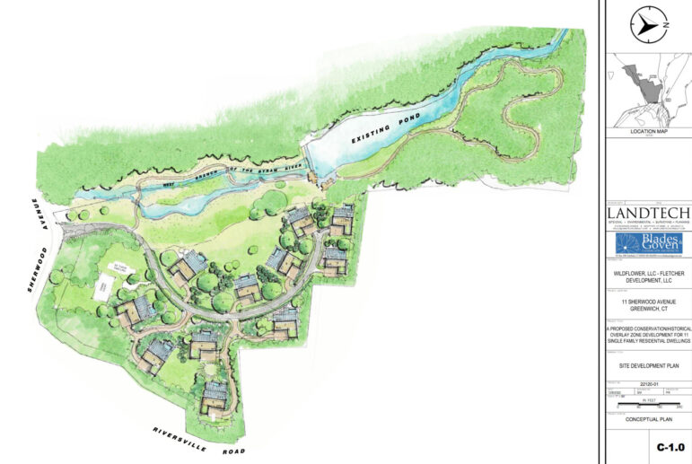
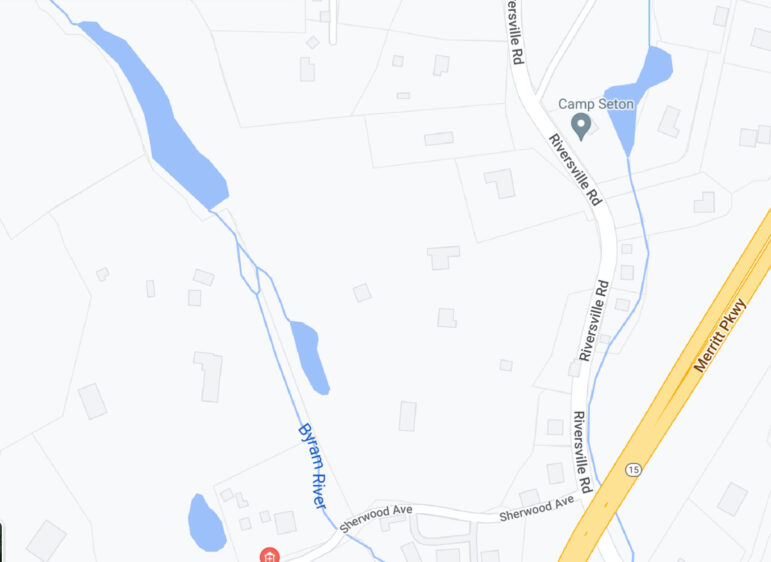
On Tuesday night a couple dozen people waited over five hours into the Planning & Zoning commission meeting to hear a pre-application from Windflower LLC to develop 11 Sherwood Ave, located at the corner of Riversville Rd just above the Merritt Parkway.
The property is approximately 28 acres. It sits on the west branch of the Byram River and is developed with three homes and a pool house. It features wetlands, a pond and a dam, and much of the feedback was water related. The existing homes are served by onsite sewage disposal systems and private water wells.
Commission feedback included concerns about flooding on the Byram River.
Certainly, this has been a theme at recent well attended meetings including a P&Z meeting where a whopping 160 people attended via Zoom for a pre-application for a large 8-30g development straddling the Byram River in Pemberwick. The proposal drew the ire of residents downstream who were flooded badly after Ida in 2021.
Last week residents packed the town hall meeting room for a meeting led by DPW deputy commissioner Jim Michel about next steps to address flooding in the neighborhood “at the bottom of the bathtub.” Residents in the area of Francine Drive, Hillside Drive, Echo Lane, Ridgeview Ave, Andrews Rd, Old Church Rd, and Plow Lane also suffered catastrophic flooding after Ida, and were unhappy to learn they are largely on their own to deal with future flooding.
A Match Made in Heaven?
The applicant at 11 Sherwood seeks two re-zones. They want to convert from RA-4 (four acres) to an RA-C4 (Conservation) Zone. And they seek to create a Historic Overlay (HO) Zone by preserving a Tudor house on the site.
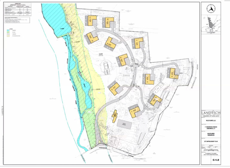
They seek to construct 11 new single family homes. Each would be served by individual onsite sewage disposal systems and private water wells.
Representing the applicant was Peter Romano from Landtech, based in Westport. Romano said his clients were Ryan and Nick Fletcher from Fletcher Development Company.
When the property was last for sale it was advertised as a family compound called “Applecrest.” According to the Assessor’s office it sold from RJ Properties to Windflower LLC on April 11, 2022 for $6,500,000.
Mr. Romano described the use of both conservation and historic overlay zones as “a match made in heaven.”
He noted that the rear piece of the property to be left undisturbed is contiguous to Greenwich Land Trust property.


Mr. Romano who said while some records indicated the Tudor dated back to 1965, it actually dates back prior to 1930. The two homes they intend to tear own are Colonials from the 1940s.
He said without the Historic Overlay, 7 lots would be allowed on the 28 acres in the 4-acre zone, but the bonus for a HO allowed for 11 homes.
The developers intend to use the Tudor as a clubhouse and possibly build a tennis court.
The property features wetlands and a flood plane, and Mr. Romano noted FEMA was getting ready to release new flood maps for the watershed that includes this property.
“They’re going to be released on Valentine’s Day to the towns,” he said, adding that the maps wouldn’t be adopted by towns for a year or two.
“From a regulatory perspective, right now you should use the 2013 maps for designing stuff,” he added.
The property also features a pond and dam, located at the northern end of the river. Romano said the dam was designated by DEEP as a “Hazard BB dam,” which, he said was on the lesser end of hazard zones. (See DEEP page 6.)
“What that means is there is no required emergency plan for this dam. In other words if the dam were to breach or fall down completely, there would be no significant damages to property or to anyone’s life,” Romano said.
“This historic overlay zone gets you the additional residences, but the conservation zone asks you to put your homes…with 40% developed and 60% left as open space,” he said. “I’m showing you 9 or 10 acres of developed area. The balance – 17 or 18 acres – stays open space.”
He said the Fletcher brothers had agonized over how to develop the property. “They took a long time to do it. They’re not your typical developers…We have an archeologist on the project.”
Mr. Romano said with a structure over than 1940, “You are entitled utilize the historic overlay.”
P&Z chair Margarita Alban said the commission was aware of FEMA flood map edits in the works.
As for submitting the application under two re-zones, she said,”We’re asking a different question. We’re asking you what you’re doing for the town, not what it does for you.”
“We are concerned about flooding in the Byram River. Since 1970 the amount of rain and flooding have increased significantly. What we’re seeing is a very delicate environmental area.”
“Because you are going for the maximum amount of density you can do on the buildable portion of the property, because the rest is wetlands, what you’re conserving is basically your non-buildable area,” Alban continued. “What does it do ecologically for our community that you’re creating this conservation zone?”
She asked what was historically significant about the Tudor building.
“By the very fact that it lists 1965, it means it has had significant alterations,” she said.
She added that the Historic District Commission would have to issue a Certificate of Appropriateness, but that HDC was only advisory to P&Z. “You need to tell us why this building allows you to max out what you can build on this 28 acres, and what ecological benefit for us (by) the fact you’re preserving in perpetuity the part of the property that can’t be built on anyway.”
Ms Alban said she was surprised to hear that former P&Z director Katie DeLuca had encouraged the applicant to couple both the Conservation and Historic Overlay regulations.
“I did not see them as something that can be additive,” she said.
Ms Alban said with a previous application for a development submitted under the conservation zone, the commission’s approval required the developer reduce the homes from 10,000 sq ft to 8,000 sq ft.
“Now that’s still a very large house,” Alban said. “But we didn’t think that was the purpose of a conservation zone.”
Alban said the town would benefit from smaller, “starter homes.”
Commissioner Nick Macri said the Historic Overlay had many requirements beside the age of a house.
“It’s got to be worth preserving,” he said. “Old and historic is completely different.”
“And, with the conservation area, what are you setting aside?” Macri asked.
Romano said there was about 6 acres of wetlands, plus some rough terrain above he described as very nice including a meadow.
“It’s a 60-40 split,” he said. “With HO there is no open space requirement.”
“You’re talking about two rezoning applications,” Alban said. “You have to be consistent with our POCD, and we would have to be convinced that this meets a significant portion of our POCD. Looking at it, it’s not convincing a first glance.”
Commissioner Peter Lowe said he also wondered what the benefit was to the town.
Commissioner Arn Welles said the proposal would result in a huge increase in impervious surface.
“I’m not sure all of that can be captured in swales and best management practices, so that will be flowing down to the river,” Welles said. “You’re probably going to have a fair amount of lawn there. And you’re going to have fertilizer, pesticides flowing down the river.”
Mary Jenkins said under a Historic Overlay, new construction should be secondary to the historic structure.
“That Tudor house is tiny compared to the 11 houses around it,” Jenkins said.
Ms Alban said previously there were HO applications where the commission “shrunk down” the second structure significantly when they didn’t find it supportive of the existing structure to be saved.
“One of the points of the HO is to preserve the surround, not only the building,” Alban said. “This is the same thing we did – I’m thinking of the Calhoun Drive application where we significantly reduced the building and we were very conscious of about what the nature of that historic neighborhood was, and… the new house looks like a gatehouse, and not a full on mansion that was originally proposed.”
“There is language in the HO that indicates it should also be consistent in terms of the setting itself,” Alban said. “The whole point is preservation, sustainability and conservation. When you’re going for these two things, you’re getting into the tree-hugger country.”
Alban suggested the applicant invite the commission to walk the property.
Mr. Romano said that was a good idea. “We’ve made that offer to the neighbors to walk the site also.”
William Caldwell, an adjacent neighbor for 84 years, described decades of flooding.
“At least a half dozen times, just the natural runoff of the property has flooded that river – the western branch to the eastern branch (of the Byram River) and closed that river and closed Sherwood Ave to Riversville Road completely for long periods of time.”
“That’s my knowledge of the property. I’ve played on that property. I’ve sledded the length of that property, down to Sherwood Ave from the top of the property.”
He said back in the time of the Civil War the Wilcox family owned a building where they operated a wheel manufacturing company.
“That whole area was known as the village of Riversville. It had a one-room school house and a general store. At one time approximately 20 years ago a younger person in the area was going for preservation for the whole area as a historic village.”
“I have owned property abutting that property. I know it well,” Caldwell said. “I have seen the lower part of that property, not just along the river, but at the very bottom, near Sherwood Ave, totally flood out. Flood out so badly that the driveway which goes to that Victorian house, you can’t get in through there.”

Adrienne Westerfield said she lived in the original house that went with the property,
The Wilcox House. The Josiah Wilcox House at 354 Riversville Road was built in 1838.
“There is flooding, but also, we have to re-rig the well all the time because there is sometimes not enough aquifer. I’m concerned about the water. We have 4-acre zoning up here, but we don’t have any sewer or water supply.
“To have this property so dense is really not in the spirit of where we live,” Westerfield added.
The pre-application was left open.