“One of the things we like to say is, ‘Where are we moving the puddle?'”
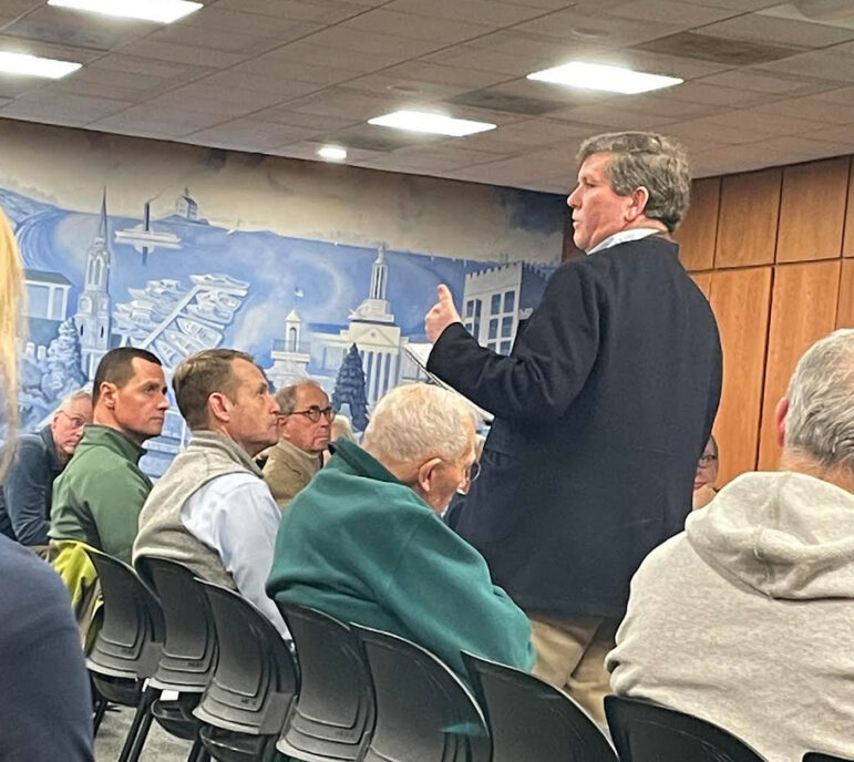
– deputy DPW commissioner Jim MichelThe first alternatives his office explored were replacing the bridges to make them bigger so they don’t back up, expanding the channel where it narrows, and exploring opportunities for upstream storage.
Also, he said non structural approaches to mitigate flooding on individual private properties were in order.
“That point at Echo Lane is the bottom of the bathtub.”
Tim Busler, Echo Lane
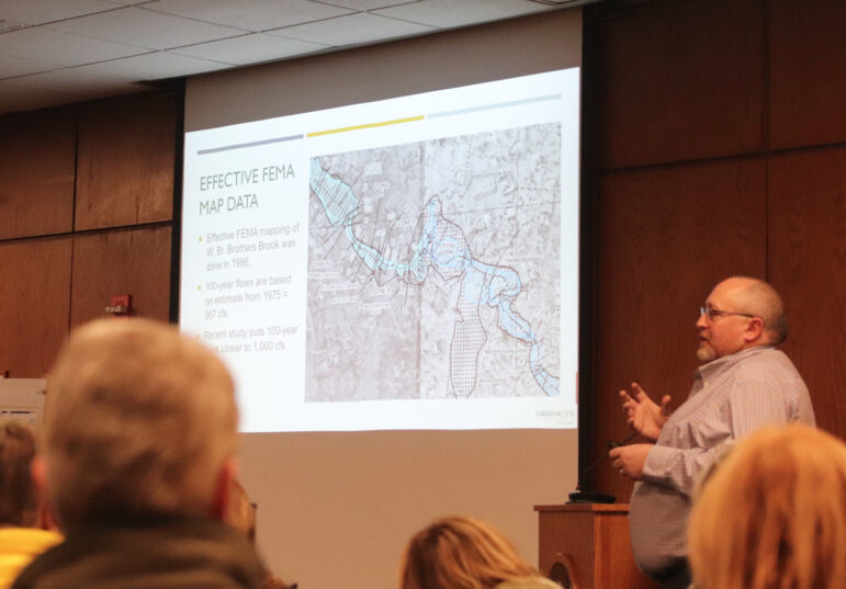
He said DPW flow models were triple that from the last time FEMA did mapping in 1975, and that based on DPW calculations, a lot of residential properties should be in the FEMA flood zone.
He described the North Street bridge as the biggest “bump.”
“If we eliminate or reduce that, it’s going to raise a bit down in the Plow Lane neighborhood,” he said. “And we’re like, that’s not good.”
“One of the things we like to say is, ‘Where are we moving the puddle?'” Michel said, adding that alleviating some areas while impacting water levels at GHS and downstream in the Milbrook Association caused a dilemma.
“And it’s also a situation where by FEMA regulations, we can’t do it,” Mr. Michel said. “We can’t make a negative impact on another area of the drainage area. We can’t just move that puddle.”
He said considerations outside the study area included modifying the concrete channel that runs behind the fields at Greenwich High school and modifying the dam at the corner of the campus that many people describe as a waterfall.
Also, he said there was a dam in Milbrook that might be modified.
“All of these come at a very significant cost,” he said. “There’s not really a great answer for this area. It is a flood zone and we need to work through that.”
“Every time we peel one layer of the onion we uncover something else.”
– Deputy DPW commissioner Jim Michel
Mr. Michel said DPW also looked at widening the channel. But, he said that would yield minimal benefit, and other than where the bridges are, the brook is primarily on private property.
DPW also considered finding areas to store water.
“We would need an area equivalent to 150 acres deep of water,” he said. “Where it would need to be would be around Husted Lane. That area is pretty well developed. There’s not a large area for that.”
To likened 150 acres deep of water to filling up the Aquarion reservoir north of the Merritt with 4-5 feet of water.
“That’s not a realistic solution,” he said.
Mr. Michel said DPW had modeled the drainage, including measuring ponding areas and slopes, and collecting information from the public.
He noted existing FEMA maps had been updated in 2013, but the result was not correct.
“And that was really just looking at the mapping and capturing of the land, it wasn’t looking at the flows,” he said.
He said the last time FEMA really did an in-depth look was back in 1986.
“In addition, you have to go back to 1975 for the last time they looked at flows,” Michel continued. “And those flows were estimates from data across the entire state.”
He said DPW estimated the amount of flow was triple that of the FEMA maps.
“These maps come from a large scale, holistic way. Our model has a much more detailed understanding of what’s happening in this area.”
Mr. Michel said flood risk management was a shared responsibility, and warned that no flood risk management project would would eliminate risk of flooding.
He shared some of the same suggestions for non-structural mitigation strategies he shared at the meeting for Pemberwick flood victims back in November, including wet proofing, dry flood proofing, elevations and ring walls.
Examples were installing flood vents and removable walls, and raising utilities out of the flood zone.
Also, he said, “You can raise your home. There is at least one property on Echo Lane that elevated their home since Ida.”
He said DPW would cooperate with property owners looking to raise their homes, and provide them with modeling, elevations and recommendations on how high they needed to go.
Mr. Michel said proposed DPW modifications were focused on roadway flooding. They provide the town’s Flood and Erosion Control Board a list to review and prioritize based on emergency access.
Mr. Michel said there was a request in the 2023/2024 budget to replace the North Street bridge, but that DPW would have to make sure they were not causing downstream impacts.
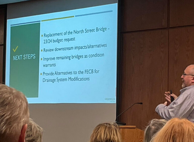
“We wanted this (flood report) to be done a lot sooner, but every time we peel one layer of the onion we uncover something else,” Mr. Michel said.
“One of the things we have seen in this town over the last 5, 7, 10 years, is we’re getting a lot more of those flash floods with three, four, five inches in two hours. No matter what happens with the design of a system…that’ the Ida model with 6-8 inches in two-hour period, that’s a very ‘flashy storm.’ We’ve seen that more recently where we’re getting two to three inches in 15 minutes.”
He said it was impossible to design the drains for these new conditions or they would be “enormously huge.”
Besides, he said, there were obstacles in the roads and the drains would become clogged by sediment buildup since they’d only be flushed out during floods.
“We will take a look at that area, but I want to manage expectations,” he said.
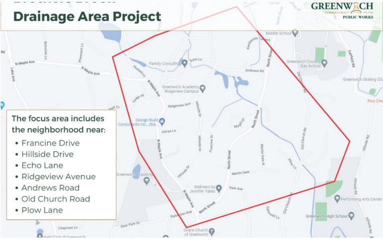
Tim Busler of Echo Lane said the primary choke point was between North Street bridge and Ridgeview bridge.
“It’s a huge flat plane, which has been a dike created by the Greenwich Academy field,” he said, and others chimed in in agreement.
One resident said before Greenwich Academy field project was approved it “acted as a sponge.”
Busler asked about the other choke points.
“Where are the slides that address the actual choke points at, One, Ridgeview bridge, Two, the North Street bridge, Three, the Plow Lane situation, and Four, the drains at 17/18 Echo Lane that were not even on the town’s maps nine months ago until we pointed them out?” Busler asked.
“In early years, Greenwich was either all rock or swamp, right? This town, and people, filled in these wetlands and part of that was the problem, right?”
– Ashley Cole, Hillside Roa
“That point at Echo Lane is the bottom of the bathtub,” Busler continued. “It’s the low point in the valley. That’s where water occurs all the time. This is a regular issue, that occurs on a recurring basis. We should stop referring to the 100-year event. I know that’s the technique for the modeling, but this is the Sept 21 2021 event, this just happened. There is plenty of evidence from people that flooding has recurred and there is evidence of notice the town has been on, and this has not been addressed.”
“Specifically, Echo Lane received four inches of additional asphalt. Not removal of millings. You raised the bottom of the bathtub without doing anything to those drains, and you are relying upon the creeks behind people’s homes, and cleaning their privately owned property, when that is removing road surface water that the state requires the drainage system address.”
Busler suggested DPW had neglected to upgrade drainage in the area for the past 20 years while the choke points continued to build.
“My final request, in addition to having the flood study itself provided to us, which we’ve very patiently waited for, but now we need both to pursue engineering project plans and to pursue FEMA money, which we’ve been waiting to do, to do this on our own as a community committee. We’ve been encumbered from doing that because you’re not giving us the first step.”
Busler said First Selectman Fred Camillo had been helpful in allowing residents to put together a ‘community committee,’ so they could in turn work with FEMA.
“But we don’t have the starting point, which is the flood study,” Busler said.
He said the town and DPW should have dealt with the problem much earlier.
“We’re looking at two decades of neglect, whether it’s misfeasance or malfeasance, but it’s neglect. There’s plenty of money that goes into building permits and transfer fees for houses, and none of that money has been plowed back into an ongoing maintenance program that would alleviate these needs that have not gotten to this critical point…These are issues that have been kept from us and we need this flood study,” Busler said.
Ashley Cole of Hillside Road asked if it was realistic to place responsibility for correcting the drainage system on homeowners.
“That flood area has been a flood area for hundreds of years,” Mr. Michel said. “That’s where the water has gone. It’s gone through this brook for many years before any of the homes were there, before anything was developed.”
“This is one of the parts of my job I hate. Trying to deliver this news. Telling you all that there’s not a whole lot I can do.” Michel said. “It is a flood way, a flood zone.”
Luke Szymczak of Andrews Road, said he wished the tax assessor was at the meeting.
“We have significant impact to assessments if you enlarge the flood zone. There’s a revenue impact to the town, because everyone else’s relative assessment (everyone) else’s tax burden will be higher as the affected homes need to be reduced.”
“I wonder if the engineers from 1975 were in the room to argue with your analysis,” Szymczak said. “I suspect they weren’t bad engineers…Obviously the flow into this area has increased. I have a problem with the concept that it’s our problem…I feel like this pointing the finger and saying, ‘Well, you just have to live with it,’ is not an acceptable answer.”
“The flood lines have changed because of a combination of more flow into that area, and not enough flow out. Departments in town have allowed development to occur, and there’s not been a thorough look at the impacts downstream. That needs to be part of the analysis,” Szymczak added.
Mr. Michel disagreed. “When we look at the rainfall data from 1975 versus today, it’s significantly higher today.”
He explained the town has a very restrictive drainage manual.
“All the projects that have come in and been developed over the years, have been required to follow those drainage regulations,” Michel said. “I’m not going to get into the political piece of ‘Are those regulations restrictive enough? Were they always restrictive enough? Those are the regulations the town has adopted. Those are the regulations the town is able to enforce.”
The current drainage manual went into effect in 2012.
Mr. Michel said his office was wrestling with whether to turn over the new information to FEMA by filing a Letter of Map Revision.
“We know that is going to impact you because if you have a mortgage on your property and you’re currently aren’t on that FEMA mapped area, and now you would be in that FEMA mapped area, you might be required to get flood insurance to have a mortgage.”
“If you were to try to sell your property you’re going to have to disclose that you’re in a FEMA flood zone,” he added. ”
Leslie Tarkington of Hillside Drive said residents in the Echo Lane and Hillside Drive area also had issues with storms exacerbating sewer issues.
Tarkington said she’d seen DEEP come on Land Trust property by Echo Lane involving heavy equipment. Asked them if they’d gone through Wetlands. She said since then Hillside Drive had been closed off with yellow tape multiple times.
“That Land Trust property has been documented as the deepest peat bog in New England, if not the northeast United States. And you’re talking about putting that additional water into that bog. Now the bog is overflowing into Hillside Drive and someone puts up yellow tape and I can’t get out of my driveway.”
Tarkington said development by the non profits was sending the water into the area.
“It’s been inadequately stored on their own property,” she said, adding, “Special privileges when they’re not in the sewer zone to send their sewers through our neighborhood too.
Peter Quigley said the complaints expressed Thursday night had been expressed for years. He described the solution as a funding issue.
“We presented this to the BET. You’re talking about a funding issue here,” Quigley said. “The problem is it isn’t being funded to the recommendations made by CDM. I believe this is simply a funding issue.”
“You need a table (showing) where you’re flooding, and present it to the BET so there is money put aside in some long range,” Quigley said.
When a resident brought up the problem of silt and debris in Brothers Brook, Mr. Michel replied, “We have water coming down these brooks like out of a fire hose and the stream is like a McDonald’s straw. “
“The amount of water trying to fit through that spot is not feasible with sediment in there…We try to keep our drainage systems clean and our catch basins clean to help with that,” he said.
“Are there also things property owners can do?” he asked. “One thing we see frequently in this town is people rake and blow their leaves into the brook. That turns into sediment over time.”
“You can talk with Environmental Affairs about getting permitted to do modifications on your own property,” he said.
Ms Cole asked about restoring wetlands.
“In early years, Greenwich was either all rock or swamp, right? This town, and people, filled in these wetlands and part of that was the problem, right?” she asked.
Mr. Michel said the regulations had been in place for many years, and have been enforced.
“Things are done differently today than maybe 50 or 75 years ago. Are there things that could be done? Possibly. Doing something like that would require funding, land, property, etc. That’s not something that the town has looked into or pursued at this point.”
Michel said private property owners could work with Wetlands to upgrade wetlands.
“It’s just a matter of going through their regulations,” he said.
A resident said while people don’t necessarily want to be policed by the town on their own properties, situations with wetlands on private property were generally triggered when there is a property transfer or application to do work on a property.
“I wonder if the town might consider, even though property owners don’t want to be policed, going through and looking at channels and giving some responsibility to the owners,” she said.
A resident likened the bottom of Ridgebrook to a Class V Rapids coming down from Ridgeview.
A resident asked if the town could give some responsibility to individual property owners to maintain them drainage pipes. “It’s the leaves, clogging up that is contributing as well,” she said.
“We don’t have the staff or people to be out there policing every little thing,” Mr. Michel responded. “However, like you stated, if there is a concern brought to the town, we sometimes get brought into those situations…It’s mostly done in response to a complaint or request by a neighboring property that something’s happening.”
See also:
Pemberwick Residents Advised by DPW to Share Responsibility for Flood Risk Reduction Nov 15, 2022