About 30 residents from the neighborhood surrounding the North Street bridge due to be replaced gathered for a Dept of Public Works input session in the Cone Room Tuesday night.
The heavily traveled bridge – between Macpherson and Cotswood – goes over West Brothers Brook, though many drivers have no reason to notice it.
“This is likely to be a 24-month period of severe traffic detouring with no benefit to neighborhoods that have suffered severe flooding problems.” – Tim Busler
Deputy commissioner of DPW Jim Michel said the session was to gather input from residents.
They had plenty.
Mr. Michel and DPW engineer Gabriela Circoha Cohee introduced design consultant Steve McDonald of WMC Consulting Engineers who also fielded questions.
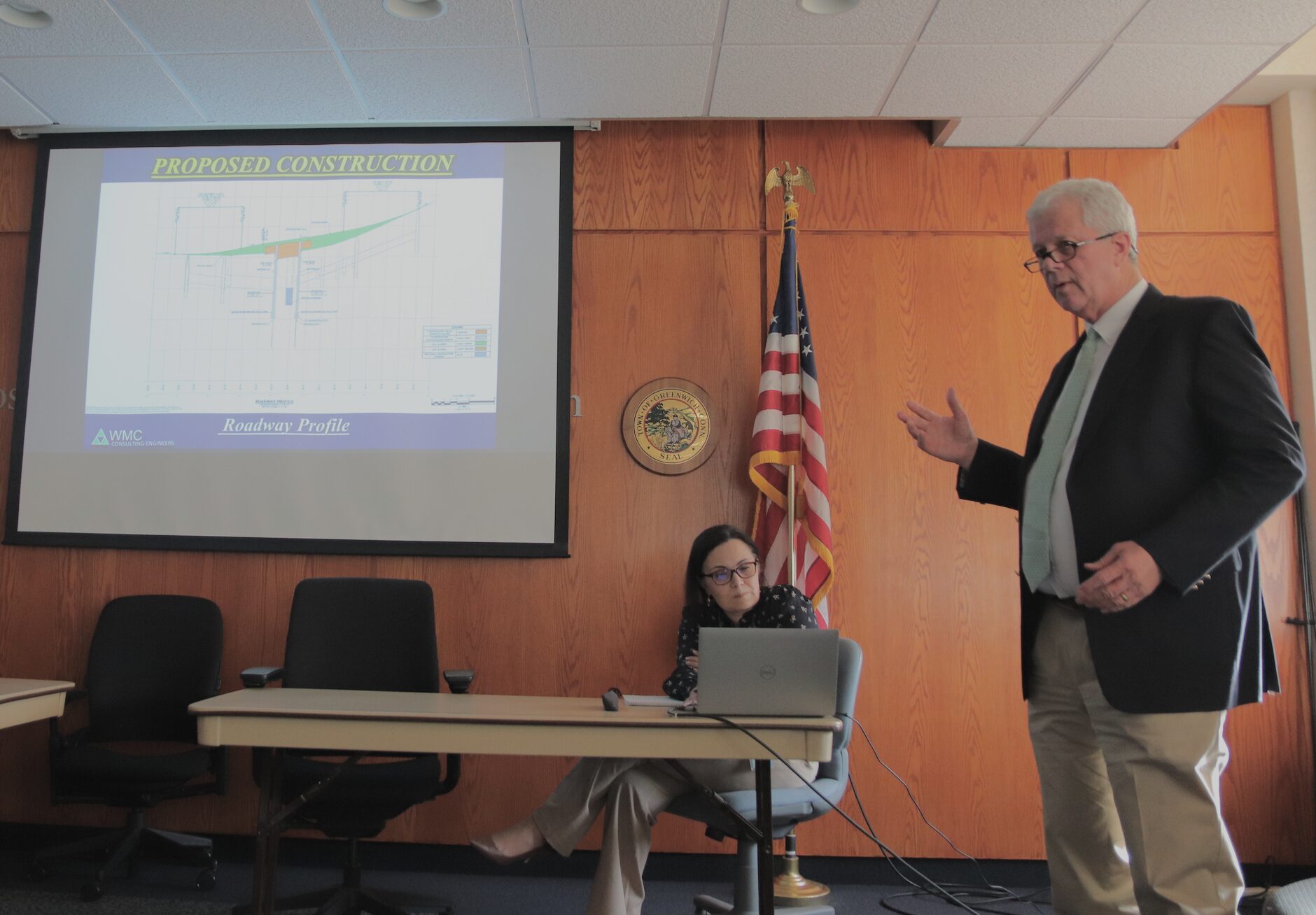
DPW engineer Gabriela Circoha-Cohee (seated), design consultant Steve McDonald of WMC Consulting Engineers at right. April 9, 2024 Photo: Leslie Yager
They said the project would take approximately 18 months (starting in spring 2025 and completing at the end of 2026), longer than would be necessary if they weren’t making the effort to keep half the bridge (one lane) open during the project. Keeping a lane open not only lengthens the project but makes it more expensive but they said they wanted to avoid closing the road completely.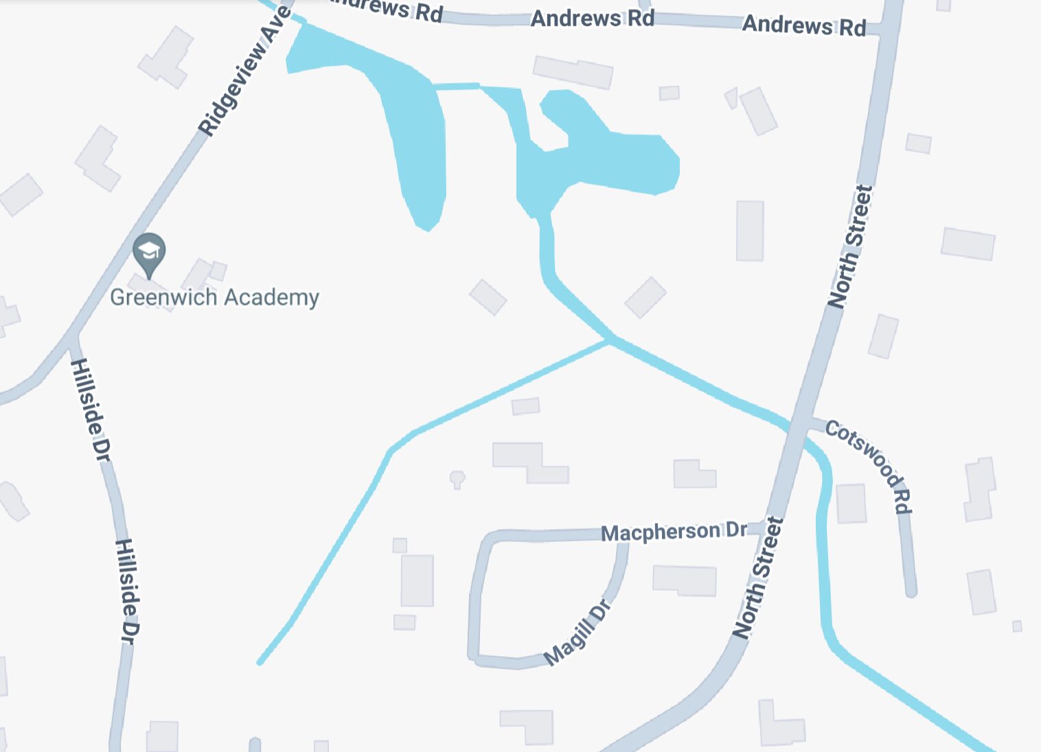
They said the project could be done in one construction season if the road was entirely closed.
It is a $3 million project, mostly being funded by a state grant from the Local Capital Improvement Project (LoCIP) program. The Town pays for design and the state grant will pay for 100% of construction.
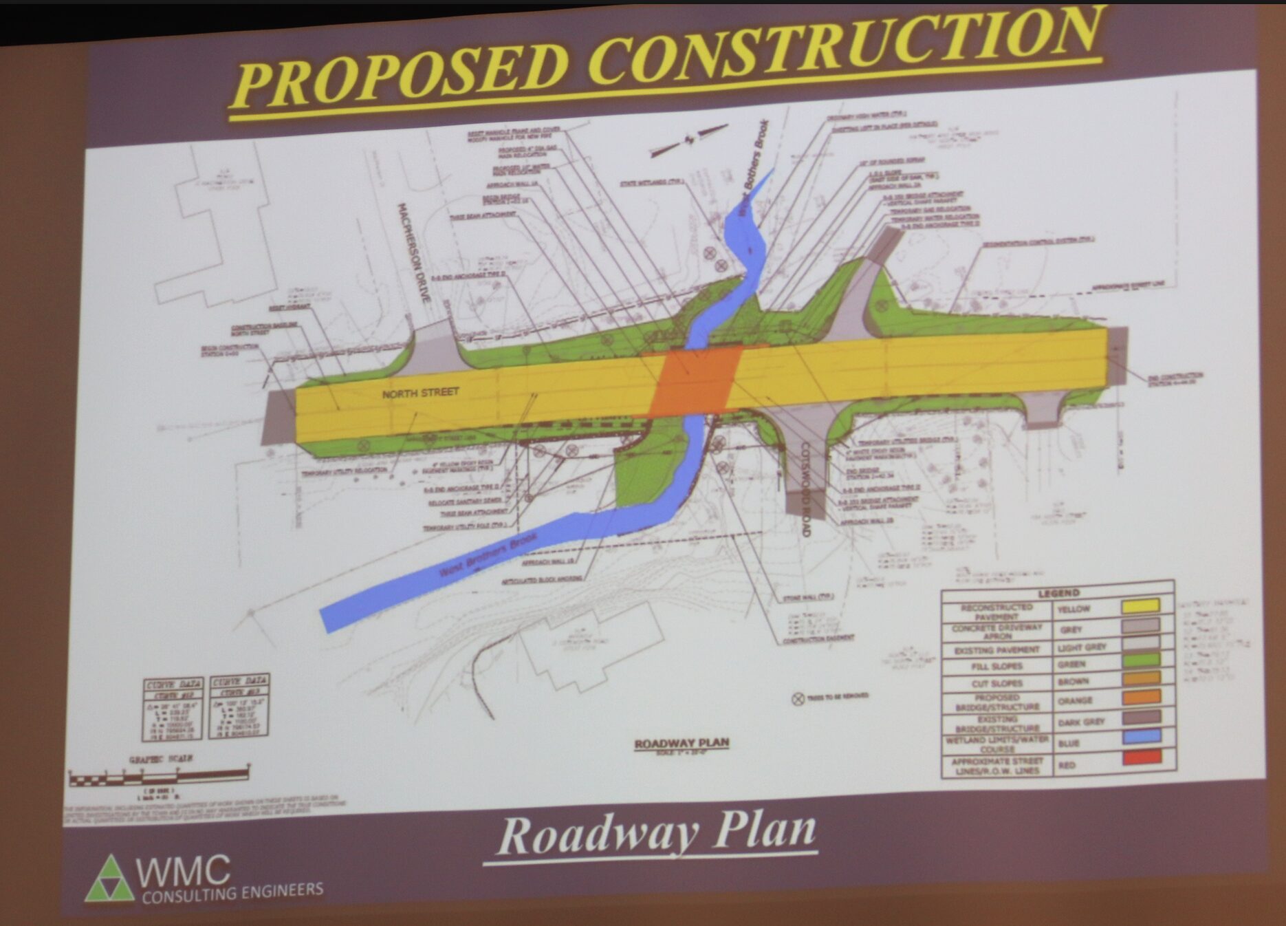
Legend. Yellow=Reconstructed pavement. Grey=Concrete driveway apron. Light Grey=Existing pavement. Green=Fill Slopes. Brown=Cut slopes. Orange=Proposed Bridge structure. Dark grey=Existing Bridge structure. Blue=Wetland Limits/Water course. Red=Approximate street R.O.W. Lines.
The project will reconstruct the bridge, enlarge the waterway opening and widen the roadway by two feet (wall to wall) to create some shoulders so pedestrians and bikers can get through more safely and efficiently.
The bridge will be raised about 2 feet from its existing profile.
The project includes new wing walls upstream and the relocation of the existing water main and gas main as well as an upgrade to the existing sanity sewer.
The new bridge structure itself will be precast concrete to last over 100 years.
Utilities will be accommodated under the bridge.
The work will involve some land acquisitions and easements and require a permit from the Inland Wetlands and Watercourses Agency as well as a permit from the Army Corps of Engineers.
Specifically they said the rights of way will have minor impacts to private properties in the vicinity of the bridge, including temporary construction easements and easements for sloping and grading.
To operate with a single lane, the town will install a traffic signal and employ a flagman so vehicles can take turns using the single lane. Construction trucks and equipment would park in the lane that is closed.
Ms Circosta-Cohee said this approach had previously worked well up Round Hill Road by the Merritt Parkway.
Residents conveyed the sense of urgency they felt, starting with their fears about the integrity of the bridge, not only given that 7,000 vehicles traverse it daily, but also because many of the vehicles are heavy trucks exceeding the 4 ton weight limit on the bridge. (No trucks are allowed on the Merritt they often exit at I95 and head north on roads including North Street and Lake Ave.)
Bridge Weight Limit
Given the bridge is in very poor condition, residents expressed concerns about its integrity, especially given the project won’t be completed until 2026.
“Fully loaded cement trucks go across that bridge every day. Big ones,” said Bill Galvin who lives near the bridge.
“Sometimes there’s two of them – two across,” said Leslie Tarkington who also lives in the neighborhood.
“If this bridge is so fragile, and we’re letting cement trucks go, there’s some disconnect here,” Galvin asked.
“We can’t control what people do,” Mr. Michel replied, adding that the 4-ton limit would be lifted after the bridge was replaced. “It will handle any legal load allowed on state roads.”
Flooding
In response to questions about incorporating the bridge project into a larger flood mitigation plan, Mr. Michel said, “We’re going to raise the low core of the bridge to allow a greater, wider waterway to allow more water go through the bridge. We can’t let it all go through unattenuated because it will flood the people downstream.”
Neighbors comments echoed those from the DPW drainage meeting from January 2023 (the drainage area that includes Francine Drive, Hillside Drive, Echo Lane, Ridgeview Ave, Andrews Rd, Old Church Rd, and Plow Lane) that left them unsatisfied about town efforts “in the bottom of the bathtub.”
Residents asked about even more water flowing through than proposed.
“We’re regulated by federal regs and FEMA,” Mr. Michel responded. ‘Within a flood zone we cannot make the conditions worse downstream.”
Further, Mr. Michel noted that while the meeting was not about flooding and was limited to the bridge replacement, DPW was working to identify potential future projects to address flooding.
He said the town conducted a study of West Brothers Brook from Old Church Road up through the Echo Lane neighborhood and some potential future projects were identified.
“In addition we started a study from Old Church Road down to to Long Island Sound that is ongoing. We’re looking for potential improvements, and then it will have to go through the capital projects funding process.”
Still many neighbors were of the strong opinion that simply replacing the bridge was a lost opportunity.
A resident who did not identify herself said flooding on Francine Drive was worsening. “It doesn’t recede. This issue has to be addressed right away. Stop by. It’s bad. It’s encroaching into parking areas.”
“To say that the traffic plan is alternating lights – I’m sorry – I’m putting on my BET hat right now, I’m not going release a condition based on that because I don’t even think that’s a plan.” – Karen Fassuliotis
Traffic Study
Residents asked DPW to do a “traffic study” to anticipate which streets would be used as cut-throughs to avoid waiting in a long queue on North Street.
Mr. Michel said the town had done traffic counts, rather than a traffic studies, which he explained were traditionally done to anticipate the impact of a new project on neighboring roads and intersections.
“The purpose of a traffic report is to show the impact of a new development on traffic,” he said. “This (bridge) isn’t changing the number of cars traveling through and from this location. A traffic report would show no change.”
Further, he said that there would be no detours since the bridge will remain open throughout the project, albeit one lane at a time.
Still, residents said existing “significant traffic problems” featured queues backing up from the bridge to Parsonage Road, that would worsen during the project and push traffic onto cut-through streets.
Leslie Tarkington noted that the area was home to numerous schools including Greenwich Catholic, North Street School, Greenwich Academy, Brunswick, Greenwich High School and GCDS.
She urged DPW to hire “a real traffic firm,” rather than rely on traffic counts done by the department.
“To compare us with Round Hill Road at Merritt Parkway just is not a comparison, Gabriella,” she said. “I think in considering this the volume of traffic…It’s enormous. So many people are going to suffer.”
“I don’t understand how emergency vehicles can get into and through these neighborhoods while this is going on,” she added.
Ms Circosta-Cohee said the signal plan’s alternating one way signals would be programmed to activate in order to give priority to emergency vehicles.
Ms Tarkington questioned how emergency vehicles could get through if traffic was backed up in both directions.
“It’s 7,000 vehicles a day – we know,” Ms Circosta-Cohee said.
“These people deserve more,” Tarkington said.
Another resident from the neighborhood, Tim Busler, spoke passionately.
“If this is in fact the public hearing that is intended to satisfy the BET’s conditions, everyone should know this money is funded by the State’s Highways and Roads Program. But all money that comes from outside grants in town must be approved and released, and there are conditions of that release by the BET.”
Given the significance of the meeting, he said residents needed to see both a design plan and a traffic diversion plan.
“If there has been no study of traffic, how can there be a plan?” he asked. “Without having such a plan, the neighborhoods effected – which are many – this project is going to connect multiple adjoining blocks and multiple adjoining neighborhoods that could stretch as far as down Milbrook and as far north as the Merritt Parkway.”
Finally, he said it was key to communicate not only with residents and neighbors, but to have the participation of Police, Fire and GEMS in the discussion, rather than just their being ‘notified.'”
“Without that communication, it’s left to individuals or associations to send out hundreds of emails or thousands of printed flyers to let neighbors know what is coming,” Busler added. “This is likely to be a 24-month period of severe traffic detouring with no benefit to neighborhoods that have suffered severe flooding problems.”
Mr. Michel said the department was following town procedures for communicating via the town website. “We did our public outreach on the project. We’ve notified those people. We cannot make people show up,” he said.
“That’s a communication plan?” Busler asked.
“That’s the approach of notifying the parties necessary,” Michel said. “We have a town website people are able to access. We post information there as available.”
Mr. Busler said the project should do more in terms of flood mitigation.
“If this bridge is replaced in its current state, it condemns the neighborhood – I’m talking about thousands of homes – to becoming part of a watershed,” Busler said. “The plan that replaces this bridge is inadequate on its face.”
Karen Fassuliotis said she was concerned about emergency vehicles being able to access Nathaniel Witherell, and with long queues of cars drivers would cut through the secondary roads, backing them up and endangering pedestrians.
“To say that the traffic plan is alternating lights – I’m sorry – I’m putting on my BET hat right now, I’m not going release a condition based on that because I don’t even think that’s a plan,” Fassuliotis said.
Peter Quigley said there were so many “choke points” that with all the development in town, Greenwich had turned into a single flood plane.
“These problems need to be solved upstream,” he said. “It comes down to funding.”
“You’re going to need more money than a grant from the state to completed this project we have had a Flood and Erosion Control Board for 70 years, why aren’t they dealing with these issues with funding?”
“We’re trying. We’ve put in requests and those requests are not being funded,” Mr. Michel said.