Submitted by Myra Klockenbrink
On Tuesday, April 26, the Planning and Zoning Commission will vote on the Mead Point development application.

Mead Point is at the terminus of Indian Field Road at Long Island Sound. This project is awaiting approval for final coastal site plan and special permit – a special over-cubic-value permit to allow for a 300,000 cubic feet structure, which is twice the allowable 150,000 cubic volume for this 8-acre size lot. Recall that this property includes shoreline and flood zone and is an ~16,000 square foot single family home with a 14-car underground garage, septic system, terrace, cabana, swimming pool, terrace, and parking court.
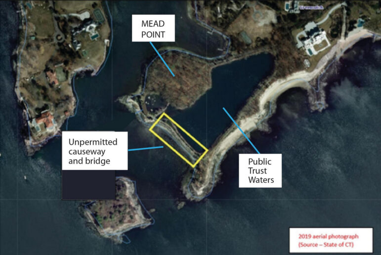
The proposed property is built on an island knoll surrounded by a mile and a quarter of shoreline that includes two tidal ponds. Through the review and discovery process DEEP has reported that the larger tidal pond was created by a causeway and a bridge, which were illegally constructed as neither has ever been permitted.
More importantly, the causeway and bridge inhibit and effectively prevent free access to public waters as permitted by the public trust doctrine, a body of law that states, “The general public may freely use these lands and waters, whether they are beach, rocky shore, or open water, for traditional public trust uses such as fishing, shellfishing, boating, sunbathing, or simply walking along the beach.” In Connecticut, a line of state Supreme Court cases dating back to the earliest days of the republic confirm that private ownership ends at the mean high water line, and that the state holds title to the land waterward of mean high water, which for Greenwich means shoreline up to an elevation of 5.5 feet.
It has been recommended by DEEP in their March 29 letter to the Greenwich Town Planner that signage be posted stating that there is public access to the tidal pond. However, the only safe way of accessing the pond is by trespassing over the causeway or bridge.
Some kayakers have accessed those waters from under the bridge, but it can hardly be considered free access when a swimmer must swim under a bridge or a boater must enter at low tide and lay down in their boat to avoid hitting the bridge. By permitting the project as proposed, the Town could open itself to liability in disregarding one of the central tenets of the public trust doctrine.
It would set a dangerous precedent for Planning and Zoning to approve this project without resolving the non-permitted status of the causeway and bridge and the issue of free public access. Already public access to our shoreline is vanishingly small as 90% of coastal properties are privately held. To effectively restrict access to public waters by approving this Mead Point application is an egregious overstep to the public trust, difficult and expensive to enforce with signage, and presents a risk of liability to the Town should anyone get hurt trying to access public waters.
As an unpermitted structure, directly on the coastline impeding access to public water, the causeway and bridge should be removed and full access restored. Putting up a sign is not restoring public access.