Update 1:00pm: On Friday afternoon Governor Ned Lamont announced that as temperatures are expected to drop into the single digits on Saturday night, he is directing the State’s severe cold weather protocol to be activated beginning at 12:00 noon on Saturday and remaining in effect through noon on Sunday.
The purpose of the protocol is to ensure that the most vulnerable populations receive protection from the severe cold conditions, which could be life threatening if exposed to the elements for extended periods of time. While enacted, a system is set up for state agencies and municipalities to coordinate with United Way 2-1-1 and Connecticut’s network of shelters to make sure that anyone in need can receive shelter from the outdoors, including transportation to shelters.
Anyone in need is urged to call 2-1-1 to get connected to these services. Safety measures have been enacted at shelters and warming centers throughout Connecticut to adhere to the needs of the ongoing COVID-19 pandemic.
Original story: Greenwich Schools canceled school for Friday Feb 4 in anticipation of potentially hazardous road conditions.
Town Hall will close at noon. First Selectman Fred Camillo said that employees who are able to work remotely are expected to do so Friday afternoon so that the Town can continue to provide services to residents.
Holly Hill Resource Recovery facility to close at 11:30am.

Greenwich Police shared an update from the State Dept of Emergency Services and Pubic Protection:
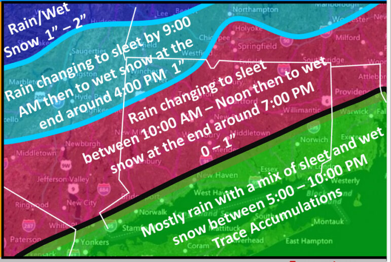
The changeover timing and ending for this storm have been pushed back a few hours in the latest model runs. At 9:00am light rain was falling across the state with temperatures ranging from near freezing in the NW hills to the upper 40’s at the southeast coast. Winds are light and shifting to the north at 5 – 10 MPH. Here’s the latest forecast based on the current Global Forecast System (GFS) and NAM (North American Mesoscale Forecast System) models:
Friday Morning: Rain changing slowly to a mix of sleet and freezing rain in the Danbury and Hartford areas between 10:00am and 12:00 noon.
Plain rain is expected along the coast and in southeastern CT. Most roads should be wet for the remainder of the morning with just a minor impact on driving. Temperatures in central CT are forecast to drop from the mid 30’s currently down to near freezing by 11:00am. Some patches of black ice may form by late morning especially on shaded and less traveled roads.
Friday Afternoon:
• In the NW Hills – Sleet and freezing rain is forecast to change briefly to wet snow by late afternoon. Some icing may occur with 1/10th to 1/4” of ice on trees and powerlines and a minor number of power outages.
• In Central CT – Sleet is forecast to continue thru the afternoon with rain in southeastern CT. Temperatures are forecast to drop into the upper 20’s in central CT and near 30 F at the coast by late this afternoon. Some of the sleet may start sticking to any untreated roads by early to mid afternoon especially in the NW and NE hills and central CT. A minor impact is expected for the afternoon rush hour with a coating of sleet or patches of black ice on shoulders, ramps and bridges where the treatment has been washed away.
Friday Evening: A flash freeze with widespread black ice is possible on roads where the treatment was washed away by earlier rainfall. The precipitation may end as a few hours of light wet snow. The overall impact of this event is expected to be minor.