All Greenwich Public Schools will be closed Tuesday, January 27, 2015.
The Superintendent will make a decision about Wednesday, January 28th during the day on Tuesday, January 27. The decision for Wednesday’s opening status will be announced as soon as possible on Tuesday.
Instructions from First Selectmen to Town Hall and other Town Employees:
Due to the severe weather anticipated for tomorrow, in the interest of
public and employee safety, Town Hall will be closed on Tuesday, January 27, 2015.
Public safety employees and all other employees assigned to storm related activities shall report to work as directed by their supervisor.
Employees assigned to Nathaniel Witherell shall also report to work as directed by their supervisor.
Employees who are required to work shall be paid according to the terms of the employee’s collective bargaining agreement.
Employees, except for Teamster represented employees, scheduled to work but who are directed by their supervisor not to report to work due to the severe weather conditions shall be paid for the day without charge to paid leave time.
Teamster represented employees who do not report to work, shall be charged a paid leave day based on the provisions of their collective bargaining agreement.
If you have any questions as to whether or not you should report to work, please check with your immediate supervisor.
We will provide periodic bulletins on storm related activities through the Town of Greenwich website, email and local and regional media outlets. Please take all precautions to be safe during this extreme weather event.
Warm regards,
Peter
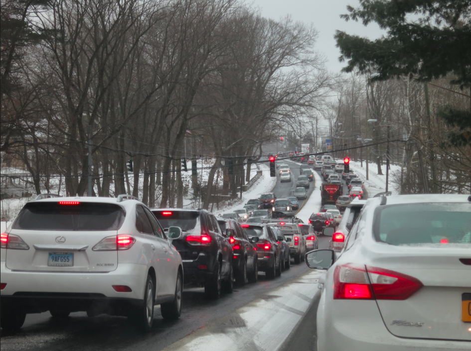
Monday, Jan. 26. AccuWeather.com is reporting that motorists traveling at the height of the storm run the risk of becoming stranded as visibility drops to zero and roads will quickly become impassable when clogged with packed snow.
A full-on blizzard bringing white-out conditions, and even thunder will likely force officials to close lengthy stretches of interstates and highways.
The worst of the storm will rage from later Monday night through Tuesday morning, when snowfall rates could reach a couple inches per hour.
MTA warns that bus, commuter-rail, and subway service could be curtailed on a route-by-route basis, depending on blizzard conditions and snow-removal operations. “As a result, commuters should consider working from home if at all possible,” the MTA website advises.
Snow emergency in effect. List of Emergency Routes – no parking or standing. Get ticketed or towed.
Sunday, Jan. 25. 8:05pm, Automated call from Peter Tesei: “A blizzard warning is in effect from 1:00pm Monday Jan 26 through Tuesday Jan 27. Heavy snow and blowing snow with projected accumulation from 20-30 inches, with higher amounts possible. Snow drifts may reach 3 ft. Snow will fall at a rate of 2-3” per hour. Snow Drifts May reach 3 ft. Winds from the north at 30-40 miles per hour with gusts possibly reaching 55-65 miles per hour.
A Coastal Flood watch is in effect for coastal low lying areas for late Monday night into Tuesday Morning with a 3 to 4 foot of surge above the astronomical tide. Residents in these areas should take action to protect their property.
Residents should take action to avoid unnecessary travel. Please monitor the Town of Greenwich website and local and regional media sources for updates. Call 911 for emergencies only. For all non-emergencies call the Public Safety Dispatch Center (203) 622-8003. Be well and be safe.”
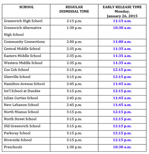
Greenwich Schools Update 7:30pm Jan 26:
Superintendent McKersie announced a 3-hour early release for Greenwich Public Schools on Monday. (As for Tuesday, Dr. McKersie will make an announcement on Monday evening.)
National Weather Service Blizzard Forecast
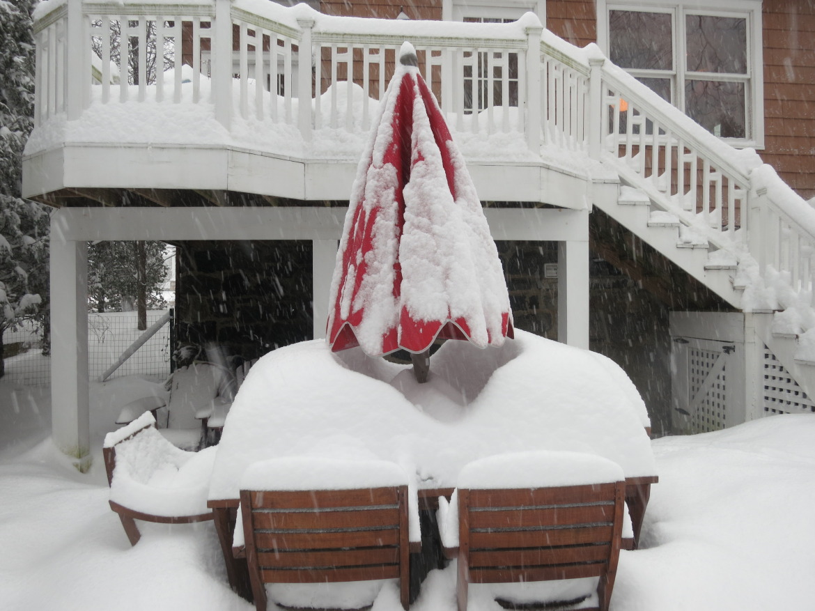
The National Weather Service is forecasting a blizzard for southwestern Fairfield County, with a possible total of 24-36″ of snow.
Beginning with light snow on Monday morning, flurries will be followed by widespread blowing snow in the afternoon.
Monday evening’s commute could be a challenge as as the storm approaches from the west with blowing snow totaling 1 to 3 inches, and a high near 25°. The storm will bring a Northeast wind 11 to 17 mph, with gusts as high as 30 mph.
The storm will become more severe Monday night with widespread blowing snow, heavy at times. Some thunder is also possible. Low around 19° with a north wind 22 to 27 mph increasing to 33 to 38 mph after midnight. Winds could gust as high as 50 mph. On Monday night, new snow accumulation of 11 to 17 inches is possible.
Tuesday will bring widespread blowing snow, heavy at times. Some thunder is also possible. Temps with a high near 21° and wind chill values between 10 and 15. Windy, with a northwest wind around 37 mph, with gusts as high as 50 mph. Chance of precipitation is 100%.
On Tuesday snow could total an additional 14 inches.
Sunday, Jan. 25, 4:45pm CL&P storm preparedness message.
A message from CL&P via phone states the utility is prepared to respond quickly. If you rely on electricity for life support devices, well water or refrigeration for medications, please prepare now to use a backup source. Visit CL&P for helpful storm preparedness information.
If you see a downed power line, always assume it’s live. Do no go near it and don’t drive over it. To report an outage, call (800) 286-2000 or on a mobile device or computer via or CL&P.